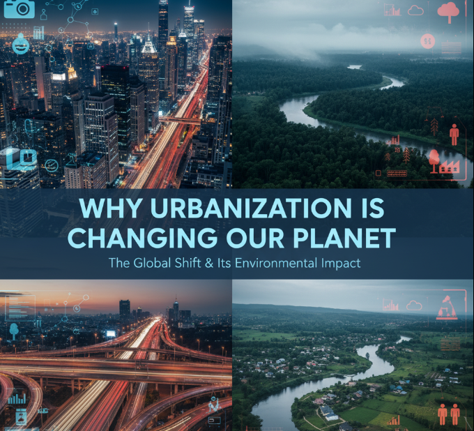
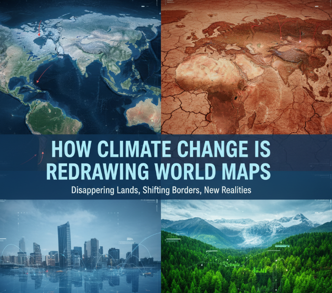
Our world is changing before our eyes, and with it, the maps we have used for centuries are beginning to show their age. Climate change isn’t just warmer temperatures or melting ice — it’s literally shifting coastlines, redefining where borders fall and challenging how we think about the maps that shape our planet. From vanishing islands to a desert that sweats at night, the geography of this planet is changing in ways that will influence billions of people.
Entire Nations Are Going Under the Water
The most dramatic way our maps will change as a result of climate change is through rising seas. And as the planet warms, glaciers and ice sheets melt from pole to pole, with giant volumes of ice dumping hundreds of billions of tons of water into our seas. Warmer water simultaneously expands, taking up more space. The result? Some countries will literally disappear and coastlines around the world are receding.
Small Island Nations Face Extinction
The Maldives, a stunning chain of islands in the Indian Ocean, averages only 4 feet above sea level. If these trends continue, scientists predict this entire country will be uninhabitable by 2100. The same fate awaits Tuvalu, Kiribati and the Marshall Islands — countries thousands of years old that now stand to be erased in our lifetimes.
These are not just statistics on papers. Real families are watching centuries-old houses that have been in their family for generations swallowed by waves. Their leaders are being forced to plan evacuations, and their governments have been negotiating with other countries to accommodate the entire population. It’s a crisis that could have sprung from a science fiction movie, but it’s happening now.
Major Cities Are Losing Ground
It’s not just low-lying islands in danger. Some of the world’s greatest and most important cities are watching their coastlines crumble. Miami, New York City, Shanghai, Mumbai and Tokyo are just a few of the world’s largest cities that will face considerable flooding risks over the next few decades. The Italian city of Venice, known for its centuries-old canals, is the latest place to confront increasing and sometimes damaging flooding.
In Bangladesh, rising waters drive millions of people in from the coastline. By 2050, the country could lose 17 percent of its land and displace as many as 18 million people. Jakarta, the capital of Indonesia, is sinking so rapidly that construction has begun on a new city in Borneo to take its place.
The Northwest Passage and the Northeast Passage Are Once Again Passable
While some places are threatened by rising seas, the melting of Arctic ice is opening up entire new waterways in a way not possible before. The Northwest Passage, a sea route that connects the Atlantic and Pacific oceans through the Arctic, used to be solid with ice most of the year. Now, in a warming world, it is becoming viable to navigate during the summer months, saving shipping companies thousands of miles.
This might sound like good news for international trade, but it’s not. Nations are scrambling to assert sovereignty over these new waters, provoking disputes over territory. Russia, Canada, the United States, Norway and Denmark have made territorial claims to the Arctic and are trying to lay claim to its resources.
The thawing Arctic is also revealing more land, which was previously covered by ice. Maps of Greenland are being redrawn this year as some 12 billion tons of water that used to be locked in the fast-melting ice cap pour into the ocean.
Deserts Are Growing and Forests Are Dying
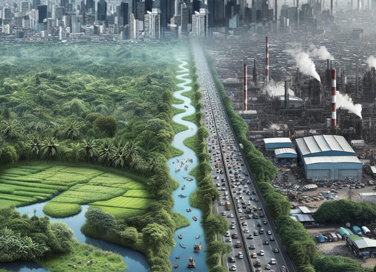
It’s not just water that climate change is affecting: The land is changing fast, too. Deserts across the globe are expanding, consuming fertile farmland and driving people from their homes. This phenomenon, known as desertification, is remaking maps across Africa, the Middle East and Asia and in other parts of the world.
The Sahara Desert’s Southern March
The Sahara Desert is encroaching on the Sahel region of Africa, which was previously grassland. The Sahara desert has grown 10% in the past century, reaching into many African nations including Sudan, Chad and Niger. Vast tracts are turning brown in some areas, while green patches disappear even in villages once so proud of their agricultural harvests.
This growth pushes populations to move, making climate refugees who need a new place to live. And, in real-world politics, it redraws political boundaries as well — the area that becomes uninhabitable desert is less worth controlling, even if borders on paper remain unchanged.
Tropical Rainforests Are Disappearing
At the same time, we are losing tropical rainforests — which help to regulate our climate. Since 1970, an area of the Amazon rainforest bigger than France has been destroyed. Deforestation that results from logging and farming accounts for much of this loss, but its severity is being exacerbated by climate change, which sets the stage for more wildfires and drought.
For the maps to be adjusted — showing agricultural land, cattle pasture or degraded forest instead of dense jungle — these forests have to vanish. This alters not just what maps look like but also changes rainfall patterns, temperature and weather systems for places thousands of miles distant.
Lakes and Rivers Are Vanishing
Some of the world’s biggest freshwater lakes are drying up at a pace that is dramatically changing regions around them — forcing mapmakers to redraw the maps and politicians to figure out how to cope.
The Aral Sea’s Tragic Transformation
The Aral Sea, in Central Asia, was the world’s fourth-largest lake before it lost 90 percent of its volume since 1960. Human water diversion projects began this disaster, but climate change has hastened it. Maps from the 1960s depict a vast body of water; today’s maps have nothing but small ponds in what is largely desert.
The dead zone which was once the Aral Sea is now known as the Aralkum Desert — an entirely new feature not marked on any maps dating back 60 years. Fishing villages that used to sit beside the sea are now stranded in an ocean of dust, kilometers from any water.
-
️ Love natural wonders? Check this out: Most Beautiful Natural Borders Between Nations
Major Rivers Are Changing Course
The world’s largest rivers are likewise changing. The Colorado River in the United States no longer extends to the sea. Lake Mead and Lake Powell, huge reservoirs created by dams on the Colorado River, have fallen to their lowest levels ever, revealing a sandy bathtub ring of bleached rock.
The Mekong River in Asia is suffering from previously rare and extreme drought. These changes affect six countries and millions of people who rely on the river for fishing, farming and transportation.
Hidden Landscapes Are Emerging With the Help of Technology
As ice sheets in Antarctica and Greenland melt, the landscapes beneath them are uncovered after millions of years. Beneath the ice, scientists are finding mountains, valleys and even evidence of an ancient forest.
Antarctica’s Changing Coastline
Ice loss in Antarctica has ramped up twice as fast over the last 10 years — about 150 billion tons a year, according to new satellite data. Ice shelves are collapsing and glaciers receding, as the continent’s coastline is transforming. Islands that were once connected to the mainland by ice bridges are becoming stranded. New passageways and bays are opening up where the ice had been solid.
These shifts are so sizable that the Antarctic research stations and bases have to redo their location maps on a regular basis. What once was a safe and stable ice shelf might be open water in just a few years.
Mountain Glaciers Are Disappearing
Around the world, glaciers in mountain ranges are melting at an extraordinary rate, dramatically altering some of the world’s most iconic landscapes.
The Himalayas Are Losing Ice
The Himalayas are facing a critical challenge. Some of the planet’s biggest rivers begin there, and millions of people depend on their water. But those mighty glaciers that so many local people called “eternal” are melting with extraordinary speed. The Himalayas hold more ice than anywhere outside the polar regions. But this “Third Pole” is melting fast. Glaciers that formed over thousands of years are melting in decades.
As a consequence of vanishing glaciers, new lakes are appearing in the high mountain valleys themselves — lakes that didn’t show up on maps only 20 years ago. Some of the glacial lakes are dangerously unstable and could burst through natural dams, unleashing floods in valleys down below.
Glacier National Park Without Glaciers
Montana’s Glacier National Park had 150 glaciers when it was created in 1910. Today, less than 25 are left and most are tiny relics of their former selves. Experts forecast that by 2030, the park may have lost all its glaciers — a tragic reversal of its name.
Maps of the park require constant updating as glaciers retreat and expose rock, and new streams and lakes form. The pattern is repeating itself in mountain chains around the world — the Alps, Andes, Rockies and mountain ranges from Africa to Asia are all watching their glaciers disappear.
Climate Zones Are Shifting
Climate zones — the broad categories we use to define whether a region is tropical or temperate, arid or polar — are changing. As temperatures climb, these zones are shifting towards the poles and higher up mountainsides.
Plants and Animals Are Migrating
Nature that once belonged to specific areas is on the move in search of suitable habitats. This means the real-world features that describe landscapes on maps are changing. Forests are springing up where there used to be tundra. Tropical-bound species are advancing into temperate climes.
These changes may not appear as dramatic as an island disappearing, but they are fundamentally transforming what various parts of the world look like and how they work. A forest ecosystem is quite different from a tundra, and the ripple effects of these shifts are felt in everything from wildlife to human activities like farming and tourism.
Border Disputes Are Emerging
As the map of physical geography is rewritten by climate change, it also rewrites the map of politics and border disputes.
Melting Glaciers Shift International Boundaries
Certain international borders are demarcated by natural land features such as glaciers or river channels. If these features shift or vanish, the boundaries get blurred. Switzerland and Italy have a dispute on their hands over where in the Alps their shared border should be because melting glaciers are changing the line drawn up by people who agreed to let it be defined by the watershed.
By the same token, when rivers that make natural borders shift course — whether because of severe droughts or flooding — nations need to hammer out new accords on where exactly the border now flows.
New Resources Create New Conflicts
Arctic ice is melting, and as it does so, valuable oil, natural gas and minerals are being uncovered. Now countries are trying to outcompete one another in order to take territory in the Arctic, creating overlapping claims and international tensions. These disputes are not just about lines on a map — they involve flexing military muscle, jockeying for economic advantage and asserting national pride.
How Cartographers Are Responding
Mapmaking science is under unprecedented pressure. Cartographers — the people who make maps — now have to update their work much more frequently than ever before.
Satellite Technology Tracks Changes
Contemporary satellites can monitor Earth’s surface with remarkable precision, spotting changes in coastlines, ice cover and vegetation. Agencies including NASA and the European Space Agency regularly monitor data that is used to update maps almost immediately.
It’s through this technology that we can capture changes as they occur, and craft time-lapse visualizations that demonstrate just how much the world around us is evolving. These visual aids are potent in forcing people to confront climate change impacts.
Dynamic Digital Maps
Digital maps do not go out of date as they can be updated at any time. That integration also means services like Google Maps and OpenStreetMap can add and incorporate new data simply by pulling it in, meaning they can show users roads as they are now rather than how they were historically.
But the standardized maps that are used in schools and government need to be more carefully and officially revised. This work takes time — so many maps in circulation today don’t reflect the latest state.
The Human Cost of Redrawing the Map
But behind each shifted coastline or vanished lake, there is a human story. Climate refugees — people displaced from their homes by conditions driven by environmental change — are already a reality, though it is difficult to know how many there are.
Climate Migration Is Accelerating
By 2050, the World Bank projects, climate change may force as many as 216 million people to move within their own countries. These are not primarily people crossing international borders (though that happens, too) but internal migrants moving away from coastlines to the interior, out of drought-stricken areas into places with more water and out of places repeatedly hit by extreme weather events to safer ground.
This mass migration of humanity is going to rewrite population maps as profoundly as physical geography. Cities will expand, rural areas will wither and the distribution of human populations on Earth will look very different than it does today.
Indigenous Communities Lose Ancestral Lands
For Indigenous peoples whose livelihoods and cultures are intimately bound to particular landscapes, these geographic shifts mean much more than a loss of land; rather they mean a loss of identity, heritage and history. When an island community is forced to evacuate, they don’t just lose their homes — they also lose sacred sites, traditional fishing grounds and the places where generations of ancestors once lived.
Economic Consequences of Changing Geography
Redrawing maps comes with big economic stakes. If the water level changes, any ports once established will be useless. Cities on coastlines might need to spend billions of dollars on protective infrastructure. Agricultural lands could get too dry or too wet for crops that currently grow well.
Infrastructure Becomes Obsolete
Roads, bridges, buildings and other infrastructure were built according to particular geographic conditions. When those conditions change — when coastlines move, rivers dry up, permafrost melts — infrastructure can become either useless or harmful.
Whole cities might have to be relocated or shielded by costly sea walls and pumping systems. The economic cost of adjusting to redrawn geography will amount to trillions of dollars all over the world.
What the Future Holds
If current trends continue in coming decades, then the maps for 2050 and 2100 will be quite different from the one we know today. How different will depend on measures that humanity takes to reduce greenhouse gas emissions and prepare for actually unavoidable changes.
Best and Worst Case Scenarios
Best-case scenario — humanity somehow reducing emissions rates and holding warming to only 1.5°C above pre-industrial times — there will be map changes, but they can be dealt with. Some islands will persist, large cities can adjust, and the most extreme effects can be avoided.
In the worst scenario — a world in which emissions continue to soar and we keep going about business as usual — the results include a dramatically different planet. Major coastal cities may be forsaken, some island nations might vanish and swarms of climate refugees could spur global instability.
Acting to Protect Our Maps
The good news is we can still shape how much our maps will need to be redrawn. Every 0.1 of a degree matters. The less we pollute now, the slower seas will rise, the less extreme weather we’ll face and the more time communities around our world will have to find ways to adapt.
People can make a difference by living sustainably, supporting clean energy and advocating for climate policies. Governments need to spend not just on emissions reduction but also on adaptation — helping vulnerable communities shield themselves from changes that are now inevitable and avoid still worse ones that have not yet, fortunately, taken place.
Conclusion
Climate change is doing something new, unheard of in human experience — it’s making the maps we use obsolete within a single generation. Islands are vanishing, coastlines retreating, deserts spreading and ice melting. These are not far-off threats for future generations; they’re occurring now, causing cartographers to redraw the map and communities to adjust or move.
The maps that we grew up with — those familiar ones laying out our continents, countries and coastlines — aren’t what our children and grandchildren will be using. The question is not whether climate change will continue redrawing world maps, but to what degree. Within the next few years the decisions we make about cutting emissions and managing changes will determine whether or not these revisions are manageable adaptations, or catastrophic conversions.
Behind each altered map is a story with real people confronting real dilemmas — families losing homes, communities abandoning the land of their ancestors, nations staking out survival. But it is also an opportunity. We would better understand the imperative to act, by understanding the ways in which climate change impacts the geography of our world. The maps of tomorrow are dependent on the choices that we make today.
Frequently Asked Questions
Q: How quickly is sea level rising?
A: The world’s oceans are rising at an accelerating rate of about 3.4 millimeters a year. This may not sound like all that much, but it adds up over decades. By 2100, seas could rise anywhere from 1 to 6.5 feet depending on how much greenhouse gases we emit.
Q: Will the map of my city change in my lifetime?
A: That’s going to depend on where you reside. If you’re in a coastal city, especially one that’s at a low elevation, expect to see major changes by the time you retire — or even sooner. Interior cities will undergo fewer of these dramatic changes to their maps, although nearby rivers, lakes and the pattern of vegetation around them may change.
Q: Are countries already moving their capital cities because of climate change?
A: Yes. Indonesia is constructing a new capital, called Nusantara, on the island of Borneo because Jakarta is sinking up to 25 centimeters (nearly 10 inches) a year through over-extraction of groundwater and rising sea levels. Other countries are having serious discussions along similar lines.
Q: Can we stop maps from changing?
A: Some future changes are already inevitable because of warming that has already occurred. But we can greatly minimize how much maps will change by sharply cutting greenhouse gas emissions. Every bit of warming we spare means less geographic change.
Q: How can scientists predict what maps will look like in the future?
A: Scientists rely on climate models — sophisticated computer simulations that estimate how the atmosphere, oceans and ice sheets will respond to various levels of warming. They also study how Earth reacted to climatic shifts in the past. Although precise predictions are uncertain, the general trends are known with confidence.
Q: What happens to a country’s borders when the land disappears under water?
A: This is complicated legally. Some island nations are contending that their maritime boundaries, even if the islands vanish, should remain the same, maintaining their right to ocean resources around them. International law is still unclear on these points, so they remain the subject of debate.
Q: Are any new islands emerging as a result of climate change?
A: In some places new volcanic islands are appearing, and as glaciers in the Arctic retreat, islands that had been covered under ice for ages are emerging as well. Yet more islands are vanishing than emerging.
Q: How frequently are official world maps updated?
A: It varies by organization. The wonderful thing about digital maps is that they can be updated on a constant basis, as opposed to government printed maps and in most schools educational materials are only replaced every few years or so. In the era of climate change, many cartographers say that maps should be updated more often than they were in previous decades.